About University
About University
Cradled in the lap of mountains at the foothills of auspicious Trikuta, besides the river Tawi at an altitude of 1030 ft. is Jammu. This 'city of temples' has many places...
Cradled in the lap of mountains at the foothills of auspicious Trikuta, besides the river Tawi at an altitude of 1030 ft. is Jammu. This 'city of temples' has many places...


One of the emerging challenges faced by any higher educational institution is the development, application and maintenance of quality...
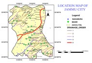
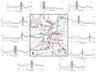
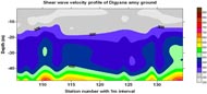
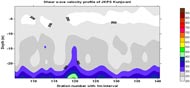
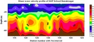
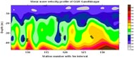
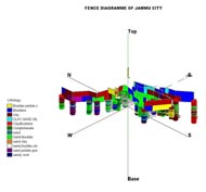
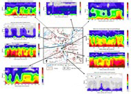
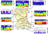
PROJECT-IV : Seismic Microzonation (Currently Ongoing Project)
Seismic Microzonation of Jammu Municipal Area in collaboration with Wadia Institute of Himalayan Geology Dehradun.
 |
 |
 |
 |
 |
 |
 |
 |
 |
PROJECT-III : Groundwater Prospect Mapping Work of Rajiv Gandhi Drinking Water Mission (RGNDWM) Phase –III of J&K State
Jammu District digital Natural Resources Information of the has been prepared by Integrating the different thematic layers in the GIS environment.
 |
 |
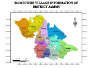
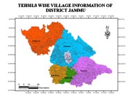
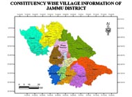
PROJECT-II : NRDMS DST Project /Centre on “Establishing the Natural Resources Digital Database District Centre at Jammu and Creation of an integrated database for Development Planning
Jammu District digital Resources Profile of Blocks, Tehsils and Constituency up to village Level showing the different assets of Socio-Economic and demography Information ( In GRAM++ and Arc GIS Software) (Scale 1:10 000).
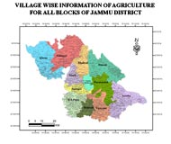
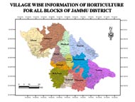
Agriculture Department information (Village wise) regarding area under different crops, source of irrigation, irrigated area, of Jammu District and Horticulture department information (Village wise) regarding area under different types of fruits, production of fruits of Jammu District.
|
|
|
|
 |
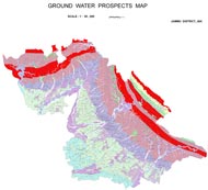
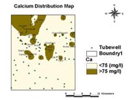
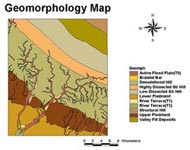
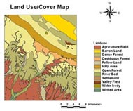
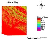
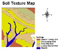
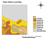
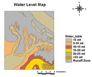
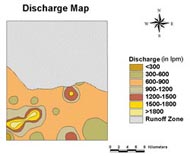
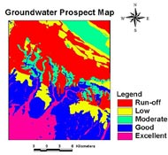
PROJECT-I : Evaluation of Groundwater potential zones using Remote Sensing and GIS Techniques in the Hills Terrain of Devak and Rui Watershed-Jammu District, J&K State
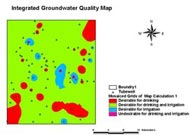
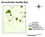
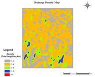
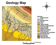
The groundwater prospects map has been prepared by integrating the hydromorphogeological, land cover, slope, drainage frequency, soil, depth to water table (pre-and post-monsoon), water table fluctuation, static water table, discharge, drawdown, specific capacity, transmissivity and hydraulic conductivity maps using Index Overlay Method in the GIS environment. Geographical Information System (GIS) based groundwater quality mapping has been carried out with the help of hydro chemical data generated from water samples collected from the study area.
|
|
|
|
 |
|
|
|
|
|
|
|
|
|
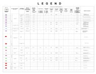
| Name | Designation | Qualification | Specialization | Contact Info. |
|---|---|---|---|---|
| Prof. A.S. Jasrotia | Professor & Head | M.Sc., M.Phil, Ph.D & P.G. Diploma in Remote Sensing & GIS | Remote Sensing & GIS | E-mail: asjasrotia@yahoo.co.ukEPABX: Mobile No.: 9419133793 |
| Dr. Ajay Kumar Taloor | Assistant Professor | M.Sc., Ph.D & P.G. Diploma in Remote Sensing & GIS | Remote Sensing & GIS | E-mail: ajaytaloor@gmail.comEPABX: Mobile No.: 9419116573 |